The field intelligence platform for GROAN — Global Reef & Ocean Analytics Network — and the empirical foundation for high-level research in cross-ecosystem ocean decision intelligence.
The Rim Run™ is GROAN Level 1 — the field intelligence layer of the Global Reef & Ocean Analytics Network, a five-level ocean decision system developed independently over 18 months as the foundation for the expedition's research. The Mobile Ocean Observation Platform (MOOP) — Shamrocket, a purpose-built Hobie Getaway catamaran with a 24-inch shallow draft — is GROAN's physical decision arm: every deployment is a decision-driven data acquisition act, tasked by the system's intelligence layers to collect field observations that feed directly into cross-ecosystem causal analysis.
All survey work is conducted using established, scientifically recognized processes and protocols drawn from the Reef Life Survey (RLS) methodology framework, the REEF survey and species identification resources, and the Reef Check tropical monitoring protocols.
The purpose of this initiative is to build a long-duration, forty-country reef observation system using the Rim Run™ expedition as a consistent field platform.
This field platform is the empirical foundation for high-level research on GROAN — Global Reef & Ocean Analytics Network. The intent is to prove that cross-ecosystem causal intelligence, produced by GROAN's Cross-Module Interaction Engine, enables decisions about ocean systems that single-ecosystem monitoring frameworks are structurally incapable of generating. Full research overview →
This field platform feeds a five-level ocean decision intelligence system. The Rim Run™ is Level 1. Everything above it converts field observations into decisions that single-ecosystem monitoring cannot produce.
GROAN is not a monitoring system. Monitoring is its input process. The system exists to produce decisions — and to prove that cross-ecosystem intelligence produces better ones.
Reef Research — Full System Overview →The goal is to establish an operational baseline data framework, collecting structured observations, and building a cross-ecosystem baseline record of reef conditions across a broad set of often undermonitored regions.
This work is being developed within DMAP-CAL™ (Decision Modeling, Analysis, and Probabilistic Control — Adaptive Logic) — GROAN's formal 22-segment mathematical decision engine. These combined resources provide a disciplined, structured foundation for data collection, helping ensure that observations are consistent, repeatable, and scientifically defensible across locations and over time.
At its core, this program is designed to unite field science, operational discipline, and long-range systems thinking. It is intended to produce a high quality monitoring architecture, a growing regional data record, a disciplined citizen science support structure, and a future research platform capable of contributing to both practical reef stewardship and formal academic inquiry.
All field operations are executed using disciplined, repeatable survey procedures derived from established reef monitoring systems. Standardized transect methods form the backbone of data collection, with consistent survey geometry, defined observation zones, and controlled swim patterns to ensure comparability across sites and conditions.
Data is recorded in real time using standardized logging formats and is subject to continuous internal validation through repetition, cross-checking, and consistent application of methodology.
Platform Intelligence
The Global Reef & Ocean Analytics Network ingests continuous multi-source environmental data across four reef theaters — the Mesoamerican Reef, the Great Barrier Reef, the Red Sea, and the Coral Triangle — resolves source conflicts, computes causal relationships between ecosystems, and delivers a single defensible output: the Decision Score.
01 — BLEACHING PREDICTION
Early Warning 4–12 Weeks Out
GROAN generates bleaching probability forecasts using Degree Heating Week accumulation curves, SST anomaly trajectories, and theater-calibrated historical patterns. Alert tiers — Watch, Warning, Alert Level 1, Alert Level 2 — are issued at site, zone, and theater level.
02 — CAUSAL ATTRIBUTION
Why Is the Reef Stressed?
When a site scores poorly, GROAN isolates the dominant stressor and traces it to its origin. Compound event detection identifies simultaneous stressors that interact multiplicatively.
03 — FIELD EXPEDITION INTELLIGENCE
Built for At-Sea Operations
Real-time Decision Score and 7-day forecast for any waypoint. Optimal dive window synthesis. Survey prioritization ranks candidate sites by intelligence value.
04 — IMAGE INTELLIGENCE (GSIN)
Field Photos → Platform Data in 15 Minutes
Underwater images submitted from the field are processed through the Global Sensor & Image Network, assigned a confidence tier, health-classified, and ingested into the decision architecture within 5–15 minutes.
05 — CITIZEN SCIENCE BACKBONE
Caribbean Coastal Reef Alliance Integration
GROAN is the processing backbone for the CCRA. Volunteer-submitted observations are QC'd against GROAN's confidence tier schema and incorporated into the Decision Score.
06 — RESEARCH-GRADE DATA OUTPUT
Publication-Ready for Institutional Partners
Normalized multi-source datasets, time-series trend exports, anomaly event archives, and theater-level health reports — all available to credentialed partners via the GROAN API.
07 — AUTOMATED ALERT SYSTEM
Continuous Threshold Monitoring
GROAN monitors all active theater locations continuously — bleaching alerts, runoff and pollution pulse detection, fishing pressure anomalies, and cascade risk alerts.
08 — POLICY & MANAGEMENT SUPPORT
Intelligence at the Institutional Level
MPA effectiveness assessment, restoration site prioritization, climate scenario modeling under IPCC SSP pathways, and fishing pressure data mapped to regulatory boundaries.
Priority is consistency over complexity — repeatable data has more long-term value than isolated precision measurements.
Surface air temperature, subsurface temperature, visibility (Secchi depth), salinity, pH, and ORP — measured at every site using standardized instruments.
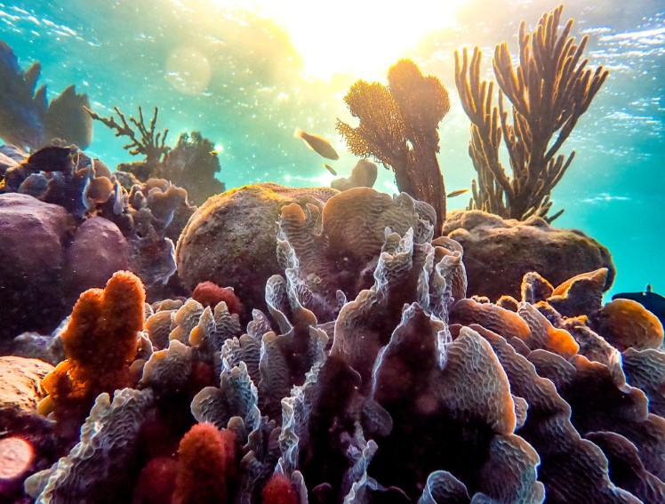
Reef type classification, substrate composition, and structural complexity — documenting the physical character and integrity of each site.
Live coral cover, bleaching extent, algae presence, disease indicators, and visible physical damage. Condition recorded across practical field categories.
Indicator fish species, key invertebrates, and invasive species — recorded as repeatable field estimates of abundance and diversity within the observation zone.
Fishing activity, anchor damage, debris, and vessel traffic — documenting anthropogenic pressures present at each site.
Standardized wide-angle, close-up, and transect-style video and photography at every site, preserving a visual record for annual comparison.
| Step | Action | Purpose |
|---|---|---|
| 1 | Anchor and stabilize vessel position | Establish repeatable site reference |
| 2 | Record GPS location and site identity | Preserve precise location reference |
| 3 | Enter water and establish observation depth | Create consistent physical survey context |
| 4 | Record surface air temp, subsurface temp, pH, salinity, ORP, and Secchi visibility | Capture full baseline environmental context |
| 5 | Conduct structured visual scan | Assess coral condition, fish activity, substrate |
| 6 | Capture photo and video documentation | Preserve visual record for comparison |
| 7 | Exit water and complete written log | Lock in observations while details are fresh |
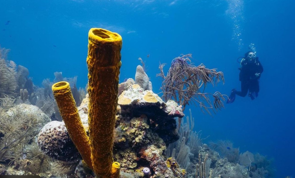
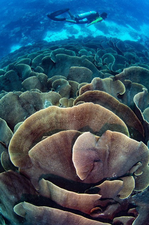
Snorkel-based observation is the operational baseline. SCUBA capability adds a fundamentally different dimension: reef walls, deeper coral structure, fish communities at depth, and benthic composition not accessible from the surface.
Reef wall documentation — vertical reef structure and deep coral colonies invisible from the surface.
Deeper fish community surveys — species and abundance at depth, including ecologically significant species.
Benthic composition at depth — substrate type and live coral cover at 10–20 meters.
Bleaching and damage assessment — direct observation at depths where bleaching events often progress differently.
Apera PCO60-Z multiparameter meter, DIY Secchi disk, underwater camera, GPS device, mask, snorkel, fins, SCUBA equipment, and standardized logging format.
Dissolved oxygen (DO) is the highest-priority expansion measurement. Hypoxic events in enclosed bay systems of the Western Caribbean have caused mass coral mortality frequently misattributed to temperature stress because DO goes unmeasured.
PAR light meter, depth profiler (thermocline detection), water sampling kit, and additional instrumentation added as partner or sponsor support allows.
The mission continues with the baseline kit. Support expands what can be measured, but does not determine whether the mission exists.
All observations are organized into a structured data system built for long-term usability. A master site index maintains a permanent record of every surveyed location. The system is designed for an observation program that runs for decades, not a single expedition.
Collected data will be made available in a controlled-access format to support research collaboration, independent analysis, and institutional partnership. Researchers, conservation organizations, and regional reef managers are invited to provide input on measurement priorities and methodologies.
Learn About the Citizen Science Program →
Always active. Visual reef assessment, photo and video documentation, basic environmental observation, and annual repeat-site continuity.
More sites, more frequent observations, stronger documentation, dissolved oxygen monitoring, and improved consistency through additional time, tools, and operational support.
When funding allows: water sampling, PAR measurement, additional environmental instrumentation, and partner-supported science initiatives.
This mission is designed to operate continuously. Support does not determine whether it exists — only how far it can go.
The Western Hemisphere's longest barrier reef system, stretching over 700 miles.
A fragmented but ecologically critical system of fringing reefs, patch reefs, mangroves, and seagrass beds.
A 2,000 km reef system defined by depth gradients, endemism, and structural formations rarely observed in Caribbean systems.
A continuous island arc stretching from the southern Lesser Antilles to the Bahamas.
FAA-licensed UAV operations support repeat photogrammetry, bleaching documentation, seagrass mapping, mangrove edge assessment, and annual visual comparison of shallow coastal habitats.
Standardized shallow-water observation and transect-based survey work targeting fish communities, key invertebrates, and reef condition using established RLS, REEF, and Reef Check process frameworks.
Reef Check-centric SCUBA surveys at selected sites throughout the route. Reef wall documentation, deeper fish community observations, and direct underwater assessment of coral structure.
Longitudinal data design, repeat-site consistency, structured logging, and internal quality control procedures built to support defensible, multi-year reef condition records.
The Rim Run™ monitoring system is designed to produce usable field observations that can support scientists, conservation organizations, reef managers, educators, local stakeholders, and future collaborative research efforts throughout the Western Caribbean.
The long-term results sought are clear: a scientifically useful multi-year reef dataset; a practical and repeatable marine monitoring architecture; a disciplined citizen science network; and a body of field-based knowledge capable of supporting cross-border collaboration and better-informed reef stewardship throughout the region.